Glycoalkaloid:
toxic
constituent in potato*
?
Megh Raj Bhandari
 Potato (Solanum tuberosum) is a major crop in many parts of the
world, with estimated world annual production of 3100 million MT. It has wide
food versatility and a full complement of nutrients. Potato is not restricted
in kitchen as household use only, but popularly used in commercial and
industrial purpose also. We can see many potato products such as french fry,
potato chips, potato powder, and several other snacks in market. Recent
investigations have pointed out about critical health threat from these tasty
tubers, due to the presence of some secondary metabolite chemicals called
glycoalkaloids.
Potato (Solanum tuberosum) is a major crop in many parts of the
world, with estimated world annual production of 3100 million MT. It has wide
food versatility and a full complement of nutrients. Potato is not restricted
in kitchen as household use only, but popularly used in commercial and
industrial purpose also. We can see many potato products such as french fry,
potato chips, potato powder, and several other snacks in market. Recent
investigations have pointed out about critical health threat from these tasty
tubers, due to the presence of some secondary metabolite chemicals called
glycoalkaloids.
?
What is Glycoalkaloids?
 Bitter
tasting steroidal alkaloids, usually referred to as glycoalkaloids, are
naturally occurring chemicals found in potatoes. Glycoalkaloids can cause
acute toxic effects and these may vary from burning sensation in the mouth,
vomiting, diarrhea, and gastrointestinal irritation to nervous system
impairment. In extreme cases, death can occur. They cause adverse health
effects at relatively low doses. Glycoalkaloid at concentration over 20
mg/100g of potato are toxic and are considered to be undesirable for human
consumption.
Bitter
tasting steroidal alkaloids, usually referred to as glycoalkaloids, are
naturally occurring chemicals found in potatoes. Glycoalkaloids can cause
acute toxic effects and these may vary from burning sensation in the mouth,
vomiting, diarrhea, and gastrointestinal irritation to nervous system
impairment. In extreme cases, death can occur. They cause adverse health
effects at relatively low doses. Glycoalkaloid at concentration over 20
mg/100g of potato are toxic and are considered to be undesirable for human
consumption.
Glycoalkaloids tend to be unevenly distributed
in the potato, being more concentrated near the outer surface and in the peel
(outer skin) (Table 1). Elevated levels of glycoalkaloids can occur in green
potatoes (due to exposure to light), unripe potatoes, potatoes damaged from
pre- or post- harvest mechanical handling, improper storage or other
environmental stress factors. Concentrations of glycoalkaloids increase during
the greening of potatoes but are reportedly much higher in potato tops
(germinating buds).
?
How to reduce the risk of glycoalkaloid- toxicity from potato ?
Toxic glycoalkaloid appear to be largely
unaffected by food-processing practices such as baking, cooking, and frying.
The highest glycoalkaloid concentration (40–60%) is in the outer layer of the
tuber, especially next to eyes and injuries. Therefore it is recommended to
peel the potatoes properly before any food preparation to reduce the toxic
glycoalkaloid contents to a safe level especially in the case of green
colored, wounded or sprouted tubers, which contain great amount of these
compounds.
**********************************************************************
Information
based on various sources of publications related to Food and Nutrition.
**********************************************************************************
Visit to Kurisawa: home-stay
experience in Japan
-Vijaya Acharya
Lainchaur,
Kathmandu
International Student Centre of Hokkaido
University organises Home-stay programmes for foreign students to familiarise
them Japanese culture. In this connection, we few Nepalese (Dananjaya and his
wife Sabina, my husband and me, and Krishna Hari dai) had such opportunity in
July 2003. In total 10 foreign students were participating. We Nepalese were in
one car and others in another. Then, we started the journey to Kurisawa. It was
my first time visit to a Japanese family, so I was very much interested to get
involved in Japanese culture.
 I was born in Pokhara, a rapidly growing city of Nepal and had no chance
to visit abroad before coming to Japan. Therefore, there were lots of thinking
in my mind about Japanese people, culture, and development. They are looked very
clean, responsive and sincere. I used to think a big difference between them and
we Nepalese people. While I was thinking about it, I saw a road-crossing, one
side directed towards Yubari. I had already heard about Yubari from my husband.
I wanted to reach there but did not say anything about it at that moment. When
we were talking and laughing, our last station had been reached. I did not feel
how fast we had travelled 1 hour’s journey. I saw a group of Japanese people in
a queue going to welcome us. In our country, such queue is for welcoming very
high honourable persons like king and queen. I surprised why they were standing
in a line. When we got off from the car, they welcomed us by clapping hand. I
was very happy with their respect to foreigners. Then, they made us participate
in the introduction programme to the host family.
I was born in Pokhara, a rapidly growing city of Nepal and had no chance
to visit abroad before coming to Japan. Therefore, there were lots of thinking
in my mind about Japanese people, culture, and development. They are looked very
clean, responsive and sincere. I used to think a big difference between them and
we Nepalese people. While I was thinking about it, I saw a road-crossing, one
side directed towards Yubari. I had already heard about Yubari from my husband.
I wanted to reach there but did not say anything about it at that moment. When
we were talking and laughing, our last station had been reached. I did not feel
how fast we had travelled 1 hour’s journey. I saw a group of Japanese people in
a queue going to welcome us. In our country, such queue is for welcoming very
high honourable persons like king and queen. I surprised why they were standing
in a line. When we got off from the car, they welcomed us by clapping hand. I
was very happy with their respect to foreigners. Then, they made us participate
in the introduction programme to the host family.
Our host family was a little bit different than others. Seemingly, he was like
an active farmer. After we got introduced to each other, he took us to his home.
On the way, we could see the Japanese villages, but the infrastructures, such as
road, electricity, and other facilities were much developed than the city area
of our country. Japanese villages seems to have very few houses in comparison to
the city areas. Our journey towards his home was very adventurous. We three
Nepalese: Krishna Hari dai, I and my husband did not understand Japanese
language well, but he was describing the local environment and we were trying to
understand. He had been in Nepal with his wife for trekking 10 years ago. We
came to know that he has a good knowledge about some tourist spots in Nepal. He
remembered all places he travelled. I surprised.
After 25 minutes car drive, we reached his home.
They have 8 years old son. The house was one storied but consisted of all
facilities like fax, telephone, computer with internet, and a vehicle. It was
different than I thought. When I saw vegetables and rice grown-up in his farm, I
felt so happy. In the evening, the host family brought us to the ward office of
Kurisawa to participate in the night programme. We participated in the dinner
and saw Japanese local dance programme. Then we returned home in late night.
Before going to bed, we talked a lot. I expressed my interest to go to Yubari.
He said that could take about 45 minutes car drive, but he did not say anymore
about Yubari. At night, it was raining, so we slept till 7 am. Then, after
taking breakfast, we went to city area again.
During the second day, they organised a programme
of making Japanese food “soba” (noodle from buckwheat). At the beginning, they
briefed how to make soba. They also made a rule of eating soba, whosoever makes
it. We enjoyed the lunch with soba at that place. The lunch place was at a
relatively high level so that we could see the beautiful scenery of the Kurisawa
valley.
Our host family
made a plan for us to go to Yubari. We were very much delighted in hearing this.
Then, our journey started the journey, and reached Yubari in 40 minutes by car.
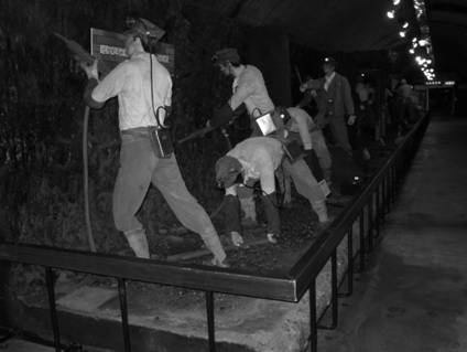
We wanted to see the coal museum. The entry fee for the museum was 800 yen per
person for students. We had a look all around the museum. Afterwards, we entered
in lift. The lift went down to 100m. We observed the coal extraction techniques
both traditional and new. I saw the hard works of labour in those time, which I
did not imagine before. I came to know that people
 had made a long and hard struggle for making Japan a rich country. Then
we entered into a long tunnel. We saw how coal was taken off from the mine. I
quivered in seeing that, how people could make such hard work. According to the
history, there was a coal mine in Yubari some 70 years ago. For many years, it
was running well. The economic condition of people was also good in that area
because of the gainful employment. Unfortunately, there was an explosion in the
coal mine and many workers lost their lives in 1948. Then, it was converted into
a museum.
had made a long and hard struggle for making Japan a rich country. Then
we entered into a long tunnel. We saw how coal was taken off from the mine. I
quivered in seeing that, how people could make such hard work. According to the
history, there was a coal mine in Yubari some 70 years ago. For many years, it
was running well. The economic condition of people was also good in that area
because of the gainful employment. Unfortunately, there was an explosion in the
coal mine and many workers lost their lives in 1948. Then, it was converted into
a museum.
The city of Yubari was beautiful, large and with
well developed infrastructures. I surprised that in all places of Japan, as I
could see in Hokkaido, the models of residential houses are almost the same. The
other aspect of Yubari is that it is also famous for melon. We wanted to buy
melons but the farm was already closed at that time. Then we returned home. On
the way I saw the apple, strawberry and cherry trees. The farming seemed
scientific and commercial.
I liked this small town of Yubari. It has Teimi
mountain nearby, green and dense forest around and a small meadow blowing in the
midst of the town. This clean city was blooming with summer flower around.
Moreover, we could also read the poem by the poet E. Tabata about Yubari. In his
Yubari: My Home Town, he has written:
When the mountains of Teimi got a flame:
with autumnal tints, white radishes
were hung on screens along the walls of
miner’ cottages and women were busy
preparing for the coming of winter…..
At night, we had barbecue at home. The
household-head, Mr. Fujiyoshi sang a nice song. We looked their photo album
covered with beautiful photos collected from their marriage, travel in Nepal,
birth of their single son Tamu, and of other occasions.
As they were farmers, so they seemed very hard
working and busy. In the next morning, the husband went to Sapporo for selling
vegetables and fruits. Wife showed us her farm, then we went to city area of
Kurisawa for having a look of the local festival. When the festival was over,
they made farewell to us. I enjoyed Kurisawa journey very much and I don’t know
how to put it in words.
********************************
Dance, dance, and dance:
impressive moments in Nepal
踊り、踊り、踊り...ネパールの思い出
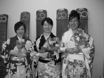
Akemi Yoda
依田明実
Sapporo
When I travel, I look forward to
spending time with local people. I especially enjoy the moment when people sing,
play music and dance. Sometimes they feel relaxed, sometimes they are drunk, and
sometimes they are celebrating… Looking at them dancing with the rhythm makes me
excited and usually I join them. Dancing opens up one’s mind, and there comes a
feeling of unity. There are a couple of places I really enjoyed dancing with
people. Nepal and Okinawa were surely impressive. I really envy people who are
living with music and dance.
{Thank you Krishna for your
patience to wait for this paragraph to come.
I hope that you
had a great time in Hokkaido and I wish you all the best! Akemi}
********************************
Introduction: Royal Chitwan National Park
Sabina Devkota
Syangja
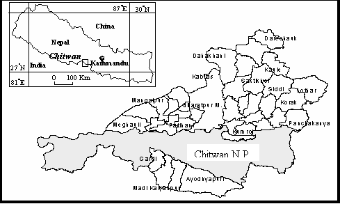
Chitwan National Park is the first and most
famous national park in Nepal. Officially established in 1973, the park is
located in the souththern part of central Nepal, covering an area of 932 sq km
of flat inner Terai and Terai regions. The park consists
a pristine area with a unique ecosystem. Topographically, it contains the
Churia hills and flood plains of Narayani and Rapti rivers. UNESCO has
declared Royal Chitwan National Park as a world heritage site in 1984.
 This
park is rich in flora and fauna. It contains both tropical and subtropical
forests. Sal (Shorea robusta) forest covers 70% part of the park. Other
types of vegetation include grassland (20%), riverine forest (7%),
sal with
chirpine
(Pinus roxburghii) forest (3%) and short grasses like impereta,
which is
used to make thatched roof of huts.
This
park is rich in flora and fauna. It contains both tropical and subtropical
forests. Sal (Shorea robusta) forest covers 70% part of the park. Other
types of vegetation include grassland (20%), riverine forest (7%),
sal with
chirpine
(Pinus roxburghii) forest (3%) and short grasses like impereta,
which is
used to make thatched roof of huts.
The park is well known for its biodiversity. The endangered Asian species
such as
one horned rhinoceros and Royal Bengal tiger are found here. The other animals
include chital, wild small cat, samber, monkey etc. Similarly Chitwan
National Park provides shelter for 450 spp. of birds and more than 50 mammal
species and 55 amphibians and reptiles.
Chitwan national park is also a most popular destination of tourist. The major
attractions of Chitwan national park are the elephant riding, beautiful Tharu
village and their culture specially the Tharu’s
stick dance. Beside this, the park is popular among the follower of Hindu
religion because of the Bikram Baba (People believed that Baba’s blessing will
help them conceive son) and Triveni. In Triveni there is Balmiki Ashram where it
is said that Sita (the heroine of great Hindu epic
Ramayana) resided while in exile.
There are many sayings regarding the origin of the word Chitwan. Some think that
Chitwan derives its name from the local word Chituwa Ban or Leopard
Forest. While others say that the park derives its name from Sita Ban
(forest of Sita), after the heroine of great Hindu epic Ramayana.
********************************
Early spring koto concert:
my
impressions
Manvi Bista

 Now (in late March), most of Honshu, the main island of Japan, is seen
busy enjoying spring and hanami while Hokkaido is still buried under snow.
Nevertheless, Hokkaido is also celebrating early spring. This is as an event for
Hokkaidoites to look forward to a wonderful spring season that is to follow
within next few weeks. In this spirit, despite of the temperature hovering
around five degree Celsius, people have already started putting on thin spring
wear. The international student center of Hokkaido University had a unique way
of enjoying early spring this year. On March 23, 2004 an early spring concert of
koto, a traditional Japanese string musical instrument, was organized at the
Clark Memorial Hall in the university. The concert was organized as the second
part of the international student forum so that the international students and
their families could have an opportunity to experience some Japanese culture.
Having been the English announcer of the concert I have had the wonderful
opportunity to absorb the music more closely that evening. Altogether six
compositions were presented in the concert. In this short article, I am going to
present my interpretation of all the compositions. The traditional Japanese
musical instrument-- koto - was in all presentations with unique variations in
its structure and flow of music. The concert was performed by Shushinrei
Fukazawa and group.
Now (in late March), most of Honshu, the main island of Japan, is seen
busy enjoying spring and hanami while Hokkaido is still buried under snow.
Nevertheless, Hokkaido is also celebrating early spring. This is as an event for
Hokkaidoites to look forward to a wonderful spring season that is to follow
within next few weeks. In this spirit, despite of the temperature hovering
around five degree Celsius, people have already started putting on thin spring
wear. The international student center of Hokkaido University had a unique way
of enjoying early spring this year. On March 23, 2004 an early spring concert of
koto, a traditional Japanese string musical instrument, was organized at the
Clark Memorial Hall in the university. The concert was organized as the second
part of the international student forum so that the international students and
their families could have an opportunity to experience some Japanese culture.
Having been the English announcer of the concert I have had the wonderful
opportunity to absorb the music more closely that evening. Altogether six
compositions were presented in the concert. In this short article, I am going to
present my interpretation of all the compositions. The traditional Japanese
musical instrument-- koto - was in all presentations with unique variations in
its structure and flow of music. The concert was performed by Shushinrei
Fukazawa and group.
(I)
The first presentation of the concert was a duet, titled Shinkyou, meaning sprit
of the poetry. The composition was an expression of a poem filled with memories
of childhood and of one’s native place. I presumed that composition had reminded
all foreigners of her/his native countries. At least I have had that feeling
while listening to this composition.
(II)
The second presentation was an ensemble or a group performance with the title
Japanesque, meaning Japanese in Latin. The composition had gorgeously-and-
calmly blended two very popular Japanese songs -- ``kouzyou no chuki..`` (moon
above ruined castle), the one among the recent ones; and ``sakura, sakura..``
(cherry blossoms), the one which has been there for centuries. One could sense
the blossoming of cherry and spring in its full splendor in this presentation,
particularly when ``sakura, sakura..`` was played in between.
(III)
The third presentation was also an ensemble. The title of the ensemble was wave,
which depicted the formation of wave in open sea and it growing bigger and
eventually hitting the rocks on the sea shore and end its short life. The
composition had simultaneously presented the power of life though the waves
often have short life. In this presentation, 17 strings koto was played. Koto
normally has 12 strings but 17-string koto is a kind of variation and one
requires more skill to play it. This variation of koto had added flavor to the
sound of wave in the presentation.
(IV)
The fourth presentation was a solo with the title sunray. The composition had
depicted the beauty of nature. It was expressive in describing the delicate
makeup of sunray and its changes even with mildest deviation of light from
above. During this presentation, one could feel the waving of leaves at a shady
area with thin ray passing down to the ground.
(V)
The fifth presentation of concert was a duet with the title Shukinsho, a
traditional Japanese musical instrument producing sound by dropping water on
jars or pots. The presentation illustrated an example of eagerness of Japanese
people to explore music in the sound of nature. The composition was a very
unique blending of traditional Japanese musical instrument - koto - and western
musical instrument-piano. This peculiar blending is probably one of the
uniqueness of Japanese people and one of the reasons for the technical progress
in the country.
(VI)
The final presentation of concert, and the attraction of evening, was a solo in
30-string koto by Shushinrei Fukazawa. It is said that there are only a handful
of performers in Japan, who can play this instrument, which requires lots and
lots of practice and skill. This kind of koto is the biggest.
The performance was a etenraku imayo variation. The variation comprised of
etenraku, which is the 1,500-year old Japanese court music originally coming
from China and imayo, which is one of Japan’s own old folk music. The
composition was originally prepared for NHK, the Japanese National Television,
around ten years ago.
The concert lasted for one and half hours. During this time, I suppose that
around hundred audience of the concert must have had their own unique
imaginations of each composition. In a nutshell, the concert was unique and full
of emotions.
********************************
A brief
introduction
of blue
sheep
(Pseudois nayaur)
Sumana Pradhan
Sankhuwashabha
 Intoduction
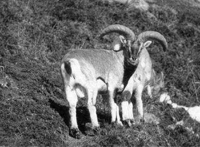
The Blue sheep, Pseudois nayaur,
is often called naur or bharal in Nepal.
It belongs to the order Artiodactyla of the sub family Caprinae of
the family Bovidae. Brein Hodgson, a naturalist (1800-1894), first
described the blue sheep as Ovis nayaur assuming it as a sheep. Later
after studying its affinities he gave the genus name ‘Pseudois’. The
animal is treated to be a goat with sheep like affinities (Schaller, 1980).
Generally two species - Pseudois nayaur (blue sheep) and Pseudois
schaeferi (dwarf blue sheep)- of Genus Pseudois are known to occur.
Physical characteristics
The blue sheep is related
to goat (Capra) and sheep (Ovis) in physical and structural
characters (Schaller, 1973). It is handsome Caprineae, covering the body
skin with ashy grey mixed with slate-blue hair. The coloration is not uniform.
In back, there is a longitudinal stripe of darker color from head to tail. The
coloration of the body becomes darker with the ages (Sherpa & Oli, 1988). The
front side of legs is black, which extends to the abdomen followed by white
hair. The colorations perfectly match with its surroundings. It has long robust
limbs, narrow erected ears and backwardly curved horns. Adult male weighs of 60
to 75 kg (Schaller, 1973).
Distribution and status
Blue sheep is found in Afghanistan, Bhutan,
China, India, Mongolia, Nepal and Pakistan (Oli, 1991). In Nepal it occurs in
north of the main Himalayan range (Schaller, 1977). The blue sheep are found in
drier mountain areas that receive about and less than 1000 mm annual
precipitation (Wilson, 1981). It is common in Dhorpatan Hunting Reserve (Wegge,
1976; Wilson, 1981), Shey Phoksundo National Park (Schaller, 1977, 1980). They
are found above the tree line (4000m) up to 5500m in northern Kanchenjuga
conservation area, too. Blue sheep is not threatened species in Nepal; it is
listed as lower risk (nt) animal in the red list of Threatened Animals (IUCN,
1996). HMG/Nepal protects the animal under schedule II of the National Park and
Wildlife Conservation Act, 2029 (HMG/NPWC, 1973).
Population and herd size
Blue sheep population in Nepal is expected to be
10000 animals in 15000km2 (Wegge & Oli, 1997). The crude densities of
blue sheep in four areas (Dhorpatan, Manang, Lapche and Shey) in Nepal ranged
from a low of 0.7 to high of 6.6-10.2/km2 (Schaller, 1977). The herd
size ranged from 1 to 162 (Sherpa & Oli, 1988,Wegge, 1976), and average group
size of 11 (Wegge, 1976).
Habit and Habitat
The blue sheep are cliff dwellers. They live in
extremely high altitude of cold climate. They are largely found on grassland or
alpine meadows dominated by Kobresia spp. mixed with Vicatia
spp., Astragalus spp., Euphorbia spp., Carex spp.,
Potentilla spp., Chesneya spp., Bistorta spp., Poa spp., etc.
When the grassland is covered by snow they survive on shrub like Potentilla
fructicosa, Berberis mucrifolia, Ephedra gerardiana, Lonicera rupicola,
Juniperus spp. etc. For the feeding purpose they move on northern slope in late
summer and early autumn (Wegge, 1976). The extensive diurnal movement can be
observed. In the early morning they go to feed on grassy area. At afternoon they
feed more and go for bedding for the night (Wegge, 1976). Like other herbivores
they have the habit of visiting ‘salt licks’ from white substance seeped from
cracks (Schaller, 1977). The main period of mating is November and December. The
young is born between April and June. The gestation period is 160 days and one
female generally gives one lamb (Schaller, 1973).
Importance
According to
Kanchenjunga Conservation Area Project, there are large numbers of blue sheep in
Kanchenjunga Conservation Area. As it is the main prey species of snow leopard (Oli,
1991), an extinct species from the world, blue sheep play vital role in its
conservation. The conservation of blue sheep also helps attract tourists for
trophy hunting. Furthermore, its conservation is necessary for balancing the
healthy environment.
References:
HMG/ NPWC, 1973. National Park and
Wildlife Conservation ACT 2029. Kathmandu: Ministry of Law of Law and Justice.
IUCN, 1996. IUCN Red List of
Threatened animals. IUCN, Gland, Swetzerland
Oli, M. K., 1991. The Ecology and
Conservation of the Snow Leopard (Panthera uncia) in the Annapurna Conservation
Area, Nepal. Thesis Submitted for the degree of Master of Philosophy,
University of Edinburgh. 155p.
Schaller, G. B., 1973. On the behaviour
of blue sheep (Pseudois nayaur). J. Bambay Nat. Hist. Soc. 69:
523-537.
Schaller, G. B., 1977. Mountain
Monarchs: Wild sheep and goat of the Himalaya. The University of Chicago
Press, 425 PP.
Schaller, G. B., 1980. Stones of
Silence, Jorneys In the Himalaya, The Viking Press, New York.
Sherpa, M. N., & M. K. Oli, 1988.
Report on Nar Phu Valley Wildlife Habitat Survey. Submitted to The WWF, USA,
and KMTNC, NEPAL
Wegge, P., 1976. Himalayan Shikar Reserves.
Surveys and Management, Proposals.FAO NEP/72/002 Field Document No. 5
Kathmanadu.
Wegge, P. and Oli, M. K., 1997. Country
Report for Nepal. In: Shackleton, D. M. (ed.), Wild sheep and goats and their
relatives. Status Survey and Conservation action plan for Caprinae, 231-239.
Wilson, A. A., 1977. The Digestibility
and Voluntary Intake of the Level of Tree, Shrubs by Sheep and Goat, Aust.J.
Agric. Res. 28(3): 501-508.
********************************
International
student
forum
in Hokkaido University
Background
Currently, 772 international students are studying in Hokkaido University from
80 different countries, and over 50 percent of these are from neighbouring
countries - China (284), South Korea (97), and Taiwan (35). The number of
students from other eleven countries - Indonesia (32), Bangladesh (27), Thailand
(25), Russia (19), Malaysia (16), Nepal (16), Philippines (16), USA (13), Brazil
(13), Mongolia (12), Egypt (10) - are in two digits. There are several
international students associations in the university with members from a
specific country and culture. Most of the students from the countries mentioned
above are involved in diverse students` activities organized by such
associations. However, there are 66 countries having students less than 10, and
out of these 34 countries have only one student. Such students are likely to
have limited interactions due to absence of broader association that they can
join. In this perspective, need of an association of all international students,
which can bring in all international students in one common ground and enhance
interaction among international students as well as their interactions with
Japanese students and beyond, is felt by many.
With my experience of attending universities in other foreign countries before
coming to Japan, I strongly believe that interaction of international students
in broader circle is not only fun but is also a mode of very effective informal
education. Therefore, I was among those expressing interest to assist in
founding an international student association in the university. Professor Seki
of international student center of Hokkaido University had called several
meetings in March 2003 to discuss on possibility of founding an international
student association in the university. I was able to participate in two of
those. During those meetings, a decision to organize an international student’s
forum was also made. Four international students (China, South Korea, Uganda,
and I) were requested to be the panelist of the forum and to have short
presentation on life of international students in the university and suggest on
what could be done to improve. A student from Myanmar was requested to present
the plan of action after the four presentations.
The forum was organized in March 23rd 2003. My simple presentation was based on
informal interviews of some international students in the university. The
presentation received varieties of feedbacks though it was intended solely to
evoke more crystallized thoughts from international students. I take these
feedbacks to be very useful for the future. The following section summarizes my
presentation of that day.
Interactions
of international students
Circle and status
The international students were found to interact the most with international
students of the same country, region, academic and non-academic interests, and
culture. Native language, English, regional language, as well as Japanese were
found to be the language of interaction in this level of interaction.
Intermediate level of interaction was mentioned between international students
and Japanese students of similar academic and non-academic interests. English
and Japanese were found to be the medium of communication for this. However, a
very low level of interaction was mentioned between international students of
different country, region, academic and non-academic interests, and culture. The
same was the case with interaction of international students with Japanese
students with dissimilar academic specialization as well as non-academic
interests. English and Japanese were the medium of communication for this.
Motive
The main purpose of interactions with varying preferences was for academics,
informal learning, daily living (sale and shopping, accommodation, traveling),
hobby and interests (sports and martial arts), outdoor activities (trips,
excursions), religion (mosque, church, temple), and parties and gatherings
(festivals, etc.).
Limiting Factors
Lack of information, time stress (academics and part-time jobs), and limited
knowledge of languag were found to be the major factors that constrained the
international students to interact in broader circle. Some students were found
to choose not to interact much in broader circle due to her/his personal
lifestyle.
Scope
Among the limiting factors, lack of information seemed to be one of the factors
which can be improved by group efforts. For this purpose, flow of information in
e-mails both in English and Japanese was the recommendation. International
students were of the opinion that such flow of information can motivate
participation.
Summing up
Some participants
had commented that the presentations from the panelists should have been
probably more uniform while some others had recommended for more time
discussion. International students agreed that an international student
association is necessary to keep up with information and flow it among members.
All agreed that such association could create environment for more interactive
life both on and off campus. The relevance of such association was expressed to
vary considerably with students` knowledge of Japanese language and their stay
in Japan, and highly relevant for new-coming students in the university. The
longer the stay or the better the knowledge of Japanese, the lesser significance
was ascribed to such association.
Conclusion
In my opinion, the
forum had been able to meet its objectivein sensitizing the international
students on the need of an international student association in the university
and also on the need of their participation and contribution to have it
established and function well. I take that the forum has opened way to form an
ad-hoc committee of the association. It has been felt the need of more efforts
to increase the active participation. I believe that the ad-hoc committee can
organize more of such fora (though it might be in different form) within next
few months to address such comments. After all, ideas come through friendly
discussions.
********************************
A trip to
Langtang and Helambu area
Dhananjay
Regmi
Syangja, Nepal
Langtang National Park, located on
the north of Katmandu, is inhabited mostly by Tamangs. It is a famous tourist
destination not only because of its easy access from Kathmandu but also it
displays the best sculptures of nature and attracts humankinds to visit there. I
planned to visit there for my research work during last October. As my trip was
intended to conduct research activities within National Parks, permission from
Department of National Parks and Wildlife Conservation (DNPWC) was mandatory. It
took about a week, as the process involves several bureaucratic hurdles.
We (Gopal Basyal ji and three
Sherpas) started our trip from Machapokhari Balaju by Kathmandu-Syabru Besi
route bus at 6:00am on 9th October 2003. We arrived at a spot of big
landslide which had damaged nearly 3 km long section of the road during monsoon
and had also swept away an army camp killing nearly 20 army personnel. We had to
cross the landslide and take a bus from other side. As we had many stuff like
tents, kerosene, and foodstuffs, etc, we were too late to pass by the damaged
section of the road; consequently by the time we arrived on the other side thee
bus was full. There was no place even on the hood of the bus where nearly 25
army personnel headed to Dhunche had already captured the place. I could guess
nearly 90 people were inside the bus which had a capacity of carrying not more
than 45 passengers.
Because we had paid full fair up
to Syabru Besi, it was our right, at this point, to claim for refund. We were
arguing for full refund whereas the bus staffs were not agreed to pay us any.
They were insisting that it was our fault not to occupy the seats in time.
Ultimately, we reached to a compromise that they would refund half the fair.
There was no option with me other than to accept this proposal. Anyway we were
unable to continue our journey at that moment and we had to wait the next bus
which was supposed to move only when it would be full of passengers. Finally, we
reached Dhunche, the district headquarters of Rasuwa, at around 9:00 pm with a
minor dispute with the bus staffs regarding our luggage. They had charged
Rs.1000 for the luggage which was hardly 80 kg and also belonging to four of us.
After a cumbersome bargaining we paid them Rs.300. It is noteworthy here that
the passenger fair from that spot (landslide) to Dhunche was only Rs.25. Our
journey from Kathamdnu to Dhunche was intervened over 10 spots for so called
security checking which has become a daily routine in Nepal recently.
Because it was already 9:00pm we
decided to stay in Dhunche that night. The DNPWC at Kathmandu had provided us
three letters one to be submitted to the National Park Office at Dhunche, one to
be submitted to the security personnel in the army camp at Ghodatabela and one
to keep with us on the off chance. Next morning we went to submit the letter and
got official permission from the National park office in Dhunche. After
finishing the official formalities we came back to Dhunche bus stand, and we
knew that there was only one bus from Dhunche to Syabru Besi scheduled at
6:00pm. As it was still early morning we decided to start trekking from Dhunche.
We bought 40 liters of kerosene and some other foodstuffs because we had heard
that there was shortage of daily commodities in Syabru Besi. We hired five
porters and started our trekking just happily walking around in the nature.
After walking nearly two hours we took rest and prepared lunch by ourselves as
we had carried all the kitchenware and foodstuffs with us. We reached Syabru
Besi about 3:00pm and then decided to stay for that night. Though we had
sufficient time to proceed further, we stayed there as Sherpas advised that he
first day is not good to walk long.
Next day, we started our trekking
along the Langtang Khola. I had already traveled most of the major trekking
routes of Nepal, such as Kanchenjunga , Sagarmatha, and Annapurna. I found
Langtang the easiest trekking I have ever made. The trekking route passes
through dense alpine forest. After walking about 4 hours we reached at Bamboo.
Bamboo is situated on a landslide accumulated debris slope. Some beautiful
lodges in Bamboo always fascinate trekkers to stay one night there but we had to
miss this opportunity to stay in Bamboo because our aims were different. After
having some cold drinks, we crossed the Bamboo and prepared lunch at the side of
the river. It was really nice to prepare food in open space with beautiful
natural scenery in background. We enjoyed it as a small picnic. We crossed Lama
Hotel at 4:00 pm and walked up to riverside and camped there. Next day after an
hour’s walk we were stopped by the army personnel in Ghora Tabela. We submitted
them one of the letters from the Park office at Dhunche and DNPWC, and then they
allowed us to go ahead. Though the burning of fuel wood is prohibited, there was
a big fire near the army camp Ghora Tabela, which of course is against the rules
and regulations of the government. After Ghora Tabela I noticed a sharp change
in vegetation. South to Ghora Tabela there are many big trees in the forest
whereas just bushes stood on the grassland in the north.
We reached Langtang at 2:00 pm. We
all were tired and none of us was enough passionate to make our food by
ourselves so we decided to eat something in the nearby restaurant. I asked
Sherpas what they preferred eating, and there was an unequivocal demand for
Chamba. “Chamba…!” I exclaimed because it was the first time that I heard this
word. The Sherpas explained me that it is a popular Sherpa dish made of oat
flour. This dish is prepared in a bowl which is first filled with tea and then
oat flour is put in the bowl such that there remains no space in the bowl. The
proper way of eating the Chamba is to start eating using ones index finger
without dropping a bit on the ground. The Sherpa friends told me that in their
community there are many cases that the father of a girl refused to let her
daughter get married with a groom only because he was failed to eat Chamba in a
proper way. It seems similar with a past tradition among the Brahmin/Chhetri
community where a boy if did not know how to make a basket was supposed to be
unable to get a bride.
After eating Chamba we walked
further and reached to Kenjing Gumba, the uppermost settlement of the Langtang
valley. There were about 20 lodges. People’s main occupation is either tourist
business or cattle rearing. I was surprised to see a cheese factory in Kenjing
which was operated by the HMG. I don’t like cheese but I heard from many
tourists that it is the best cheese they ever ate in their life.
 There
was heavy snowfall that night in Kenzing. Next day the Kenzing looked like a
paradise. I found most of the tourist walking on snow and playing with it. It
was very beautiful. The fresh and white snow was gleaming on the sunlight. The
tiny grains of the snow were exposing their importance to beautify the mountain
slopes. Far in the horizon the white snowy mountains were kissing the deep blue
sky. The sun at the middle of the sky was shining in joy. Some grasses peeping
from the snow blanket and nodding themselves according to the wind were
welcoming the people in that nature’s paradise. I felt the mountain slopes
saying “Hey! Hey! Nepalese! This is your pride! This is your wealth! Cash it!”
But alas! Those lifeless mountain slopes, that clean and blue sky, those tiny
snow particles might not know that Nepalese are still in deep asleep and they
will hardly awake when they loose everything.
There
was heavy snowfall that night in Kenzing. Next day the Kenzing looked like a
paradise. I found most of the tourist walking on snow and playing with it. It
was very beautiful. The fresh and white snow was gleaming on the sunlight. The
tiny grains of the snow were exposing their importance to beautify the mountain
slopes. Far in the horizon the white snowy mountains were kissing the deep blue
sky. The sun at the middle of the sky was shining in joy. Some grasses peeping
from the snow blanket and nodding themselves according to the wind were
welcoming the people in that nature’s paradise. I felt the mountain slopes
saying “Hey! Hey! Nepalese! This is your pride! This is your wealth! Cash it!”
But alas! Those lifeless mountain slopes, that clean and blue sky, those tiny
snow particles might not know that Nepalese are still in deep asleep and they
will hardly awake when they loose everything.
We stayed at Kenjing for two days
until the snow melted away. We left Kenjing on October 7. It took 5 hours to
reach Dakpatan Platue from the Kenjing. It was the place of my research
interest. Most of the ground is covered by debris or talus with sparse
vegetation. Here many landforms evolved by past glacial, and periglacial
processes are well displayed. In fact this place served me a natural laboratory
to study glacial-periglacial processes and their consequences. I remembered the
statement “Present is the key to the past” and tried to think different factors
involved in the nucleation and evolution of the present landforms. The
environment was very calm without any pollution. Ultimately our purpose of
visiting this place was completed; I made important notes, sketches, and
physical measurements like temperature. Then we returned to Kenjing after 15
days’ field study.
From Kenjing we climbed up the
southern mountain range. The following two days were very hard for us to cross
the most difficult and dangerous part of this area named Ganjala Pass. South to
Ganjala pass, there is another beautiful valley called Yamatari valley. It is
the glaciated valley without any vegetation and settlement. We spent 15 days
here studying various aspects of glaciations. We had planned to return back to
Kathmandu via Helambu and Melamchi. So we stepped downward to Helambu. We could
not make our journey to Helambu in one day and had to spend one night in the
middle of the jungle making a fire. It was the most horrible time I had ever
experienced in my life. In Kenjing side there were many fountains and plenty of
water, whereas in Yamatari side there was no water between lower part of
Yamatari and Helambu. Yamatari Valley, where we had made our camp for 15 days,
was the only place with water. All of us were new comers to this region and we
thought that this region would also be enriched by water resources like the
Kenjin region so we carried only a couple of bottles with water which was
finished by 10:00am. Then we started searching water and here we were deceived
by the nature. We found streams but without water, they were all dry! We had
passed a long distance with up and down steep foot trails and obviously were
very tired. The trekking in Kenjing side was the easiest trekking in my
experience but the Helambu side was the most difficult one. Anyway in the
evening at 5:00pm we found one small dewpond where water was accumulated from
nearby saturated soil, I could guess there was nearly three liters of water in
the pond.
After that we took out some Chamba and sugar. Then stirred them up with water
and ate and even drank! It was
bad from hygienic point of view
but relative to that particular moment of time, when we all were dying of thirst
and hunger, the issue of health was not prime. I remembered a small tale about
Akabar and Birbal that once upon a time Birbal created such a circumstance that
Emperor Akbar came in agreement with Birbal that the taste of a dish does not
matter but the thing that matters is the hunger. Of course the Chamba was very
delicious! Water of that small pond was not sufficient to quench our thirst but
it supplied an overwhelming energy to think about anything other than thirst and
hunger at that time. Afterward, we decided to go little down slope hoping that
there may be some source of water. But unfortunately there was no water. Since
it was getting dark, we decided to camp very soon. But there was no water and
even no enough space to fix our tents so we kept walking under dim beams of
torchlight. Finally, after an hour walk we stopped on a small but flat area with
a small shed. We pitched our tent there and then roamed in search of water. Four
of us headed to four different directions but the fortune was against us, we did
not find any drop of water. We decided to eat popcorn. There was a big cabbage
left with us, we ate popcorn with cabbage salad without a drop of water and
slept with a hope that we could find sufficient water the next day. Next morning
we woke up at 5:00, packed the tent and our rucksack and proceeded towards
Helambu, our destination. This morning was really a very good morning because
after a 10 minutes walk we found a big source of water. We were blaming each
other to be responsible for the decision of staying a few yards up hill last
night. Everyone was regretting for missing good Haps (food) and good sleep.
We finally forgot everything about last night, and prepared tea. After having
tea and biscuits the journey was again started. After about 10 minutes we saw a
yak shed and some people. We reached there. From this yak shed the village of
Helambu was seen very near. We were very excited to see the beautiful and famous
village of Helambu. We drank hot milk and then gave our remaining foodstuffs and
the kerosene to the herder. We reached Helambu after one and half hour from the
yak shed. It was a clean and beautiful village with all the houses preserving
ancient design. In the middle part of the village there was a Gumba, of course
all the people in the Helambu are Buddhists. The Helambu village is very famous
for apple production in Nepal, and Helambu apples used to be compared with red
chicks of a beautiful lady. But in fact there is no apple production in Helambu
at the present day. According to local people there were many apple gardens even
in the jungle some 50 years ago. But, later all the apple gardens were
devastated by some kind of unknown diseases. People did not notice and even did
not care it, particularly because there was no market for Helambu apple. Because
of the lack of the means of transportation, apples even carried to Kathmandu by
using porters were not economically viable. But now Helambu is somewhat accessed
by the Kathmandu Melamchi road, people at Helambu have again started apple
plantation. Next day, we walked nearly six hours and reached to Melamchi.
Luckily we were able to get the last bus for Kathmandu. And at the evening at
about 8:00 we were back to Katmandu.
********************************
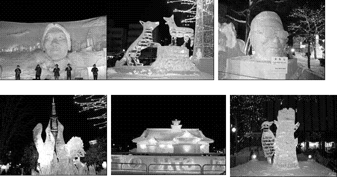
;+ho lu/L
hfkfgsf] xf]SsfO{8f] l:yt
;fKkf]/f] zx/df x/]s jif{ cfof]hgf ul/g] ;fKkf]/f] lxpF kj{ hfkfgsf] dfq geO{
ljZjs} a[xt\ lxpF kj{x?dWo] Ps dflgG5 . of] kj{ x/]s jif{ k]ma|'j/L dlxgfsf]
klxnf] / bf]>f] xKtfsf] aLr s'g} ;ft lbg kf/]/ dgfOg] ul/G5 . of] kj{sf] a]nf
;fKkf]/f]df ljz]if u/L hfkfgsf cGo zx/sf tyf ljb]zaf6 klg nueu @) nfv ko{6sx?
cfpg] u5{g\ . o; kj{df lxpFn] agfOPsf ;fgfb}lv lnP/ cToGt a[xt\ lxd k|tLdf, b/jf/
cflb O{Toflbsf] k|bz{g ul/G5 . ;f] k|tLdfx? ;fKkf]/f] l:yt cf]bf]/L gfdsf]
au}+rf -zx/sf] pQ/ / blIf0f efu 5'6\ofpg] sl/a Ps ls= ld= nfdf] au}+rf_ tyf
dfsf]dfgfO{ Pj+ ;';'lsgf]sf ;8sx?df lgdf{0f ul/G5g\ .
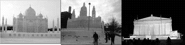 o;
kj{sf] k|f/De ;g\ !(%) df ;fKkf]/f]sf dfWolds ljBfno :t/sf ljBfyL{x?n] ^ j6f
lxd k|tLdf cf]bf]/Ldf lgdf{0f u/]/ ePsf] lyof] . To:sf] % jif{ kl5 cyf{t\ ;g\
!(%% df hfkfgsf] cfTd/Iff kmf}hsf] ;xefuLtfdf lxpFsf a[xt\ k|tLdf, b/jf/ cflb
klg agfOg] k|yfsf] z'?jft eof] . o; k|sf/ of] kj{ la:tf/} la:tf/} ;+;f/el/ g}
VoftL k|fKt kj{sf] ?kdf ulgg] eof] .
o;
kj{sf] k|f/De ;g\ !(%) df ;fKkf]/f]sf dfWolds ljBfno :t/sf ljBfyL{x?n] ^ j6f
lxd k|tLdf cf]bf]/Ldf lgdf{0f u/]/ ePsf] lyof] . To:sf] % jif{ kl5 cyf{t\ ;g\
!(%% df hfkfgsf] cfTd/Iff kmf}hsf] ;xefuLtfdf lxpFsf a[xt\ k|tLdf, b/jf/ cflb
klg agfOg] k|yfsf] z'?jft eof] . o; k|sf/ of] kj{ la:tf/} la:tf/} ;+;f/el/ g}
VoftL k|fKt kj{sf] ?kdf ulgg] eof] .
x/]s jif{ lxpF kj{ z'?
x'g'eGbf s]lx lbg cl3 cGt/f{li6«o lxd k|tLdf lgdf{0f k|lt:kwf{ klg x'g] u/]sf]
5 . o; kfln ePsf] #! cf}+ lxd k|tLdf lgdf{0f k|lt:kwf{df !* b]zsf 6f]nLx?n]
efu lnPsf lyP, h;df :jL8]g, yfO{Nof08, xËsË, dn]lzof / rLgn] % pRr :yfg k|fKt
u/]sf lyP .
o; jif{ cfof]hgf ul/Psf]
%% cf}+ lxpF kj{df xf]SsfO{8f] ljZjljBfnosf O{lGhlgol/+u zfvfdf cWoog/t ljb]zL
ljBfyL{x?sf] ;+3n] klg s/La @ 3g ld6/sf] Pp6f ;fgf] k|tLdfsf] lgdf{0f u/]sf
lyP . ;f] k|tLdfsf] gfd ÆzflGtsf nfuL xftx?Æ eg]/ /flvPsf] lyof] . ;f] %% cf}+
lxpF kj{df agfOPsf lxpFsf cfsif{s k|tLdfx?dWo] tfh dxn klg Pp6f lyof] .
;f] lxd kj{sf] a]nf
lvlrPsf s]lx t:jL/x?M
********************************
Transport sector development in Nepal: an
overview
Prakash Ranjitkar
Malangwa-8, Sarlahi
A balanced, well-coordinated and efficient
transport system is a prerequisite for the sustainable economic growth of a
country. This task is more challenging and sensitive particularly for a
landlocked country like Nepal, where more than 90% of its total population is
living in remote rural areas.
Road is the principal transportation mode in
Nepal and this position is unlikely to change in the foreseeable future. The 376
km of road length in 1950 has been stretched to 15,308 km till 2000. According
to Nepal Road Statistics 2000, there is 4,522 km of black topped roads, 3,646 km
of graveled roads and 7,140 km of earthen roads. The development pace has
increased significantly since 1990. The principal focus was on graveled and
earthen roads.
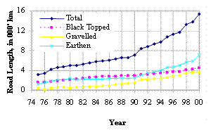
Fig. 1
Nepal Road Statistics since 1975
Source:
DOR, Nepal
Being the most dominant transportation mode, the
efforts are underway to improve the management of road systems under the
following four strategic steps:
o
Strategic network consolidation
o
Strategic network development
o
Rural network development
o
Transport service delivery
improvement
Nepal has a single railway link
52 km long operating in the eastern Terai, and in fiscal year 1994/95, some
1,117,686 persons and 6,869 metric tons of freight were transported. The efforts
are underway to operate the newly built inland container depot near Birgunj, a
boarder town on south.
Foot trails and mule tracks are another
important and popular transportation mode in Nepal. Some 16,000 km of trial and
tracks connect rural villages (mostly in hilly areas) with administrative
centers and national roadway systems. There are villages where it takes upto 13
days to walk from the nearest motorable road. 17 out of 75 district headquarters
are still accessible only by foot trails. Some 3.5 million people (15% of the
total population) are living in the hills without any access to road system.
Out of 42 km of ropeways, only 13 km of its
length is in operation. The government is trying to develop a system in which
the donor agencies can fund for their chosen projects without getting involved
in the government’s internal procedures. The maintenance of the existing
suspension bridges and construction of 10-15 new bridges annually are the
current requirements.
There is one international airport in
Kathmandu, 6 regional airports with asphalt surfaced runways, and 36 other
airports with grass, gravel or earth strips. Commercial air services are
available in 44 out of 75 districts in the country. The domestic air systems
count for 1,182,000 person-trips and 4,600 metric tons of freight services, for
international air systems counts for 844,000 person-trips and 14,060 metric tons
of freight services during fiscal year 1994/95. Helicopter services are being
used as alternative mode in some more remote and inaccessible area. The
participation of private sector in air systems is encouraging. The construction
of a new international airport in central Terai is under consideration. This
also means that the existing road links with Kathmandu needs to be upgraded.
Water transport is considered as the cheapest
transportation mode, however commercial water transport has very limited
potential and still in preliminary stage in Nepal mainly due to highly rocked
topography. Some large rivers have potential to connect some Terai towns with
Indian water systems.
As mentioned
earlier, transportation is only the basic need, while a lot depends on how other
sectors e.g. agricultural, tourism, industrial, trade etc. respond, grow and
sustain the country’s economic development needs.
********************************
Trekking,
mountaineering,
safari
and rafting
tourism
in Nepal
Narendra Raj Khanal
Tanahun, Damauli
 Introduction:
 Tourism is one of the major economic sectors of Nepal. Tourism accounts
for 13-15 percent of all foreign exchange earnings and provides 6.8 percent of
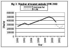
total employment in the country. The number of tourist arrivals has increased
from 6,179 in 1962 to 361237 in 2001 though the trend has been declining since
1999 due to recent political instability and Maoist insurgency in the country (Fig. 1). Being a
mountainous country and poor road network, more than 83 percent tourist arrival
is by air. Countries such as Japan, UK, USA, Germany and France are major source
of tourists each comprising more than 5 percent of the total tourist arrival in
the country. Every year more than 17,000 Japanese visit Nepal.
Tourism is one of the major economic sectors of Nepal. Tourism accounts
for 13-15 percent of all foreign exchange earnings and provides 6.8 percent of
total employment in the country. The number of tourist arrivals has increased
from 6,179 in 1962 to 361237 in 2001 though the trend has been declining since
1999 due to recent political instability and Maoist insurgency in the country (Fig. 1). Being a
mountainous country and poor road network, more than 83 percent tourist arrival
is by air. Countries such as Japan, UK, USA, Germany and France are major source
of tourists each comprising more than 5 percent of the total tourist arrival in
the country. Every year more than 17,000 Japanese visit Nepal.
Nearly 52 percent tourist visits Nepal for pleasure and holiday, 28 percent for
trekking and mountaineering, 5 percent each for business and official work, and
remaining 10 percent for other different purposes.
Trekking and Mountaineering:
The number of tourist 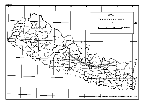 visiting
Nepal for trekking and mountaineering purposes has increased tremendously. In
1960s, the percentage of tourists visiting for trekking and mountaineering
purpose was less than one percent of the total tourist arrival in the country.
This proportion increased to 28 percent in 2001.
visiting
Nepal for trekking and mountaineering purposes has increased tremendously. In
1960s, the percentage of tourists visiting for trekking and mountaineering
purpose was less than one percent of the total tourist arrival in the country.
This proportion increased to 28 percent in 2001.
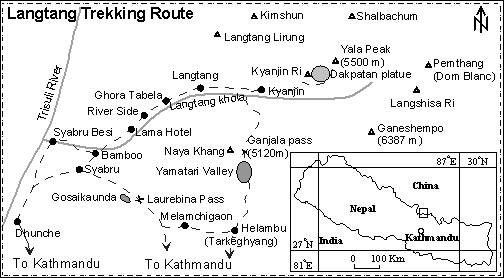
There are many areas for trekking in Nepal. Three main areas which are commonly
used for trekking in Nepal are Everest (Khumbu) in the eastern part,
Langtang-Helambu valleys in the central and Annapurna area (Manang-Jomsom-Pokhara)
in the west (Fig. 2). Annapurna area is by far the most important trekking route
in Nepal and more than 76000 trekking tourist visit this area.
Khumbu (Everest) is another most important area for trekking and more than 27000
tourists visit this area. Langtang-Helambu is the third important trekking
routes with more than 10000 trekkers every year.
There are other controlled areas such as Dolpa, Upper Mustang, Humala, Manasalu
and Kanchanjunga which are used for trekking. Every year more than 1000 tourists
trek to Dolpa and Upper Mustang. The number of trekkers to Humla, Manasalu and
Kanchanjunga is less than 1000 in a year. Till now trekking tourism is confined
in limited places. Though there are many other places which can be developed for
trekking tourism, in the absence of tourism related infrastructure facilities,
they are rarely used.
 The
government has opened some mountain peaks for trekkers. The commonly used trek
peaks are Pisang, Chulu East, Kangja Chuli, Tharpu Chuli, Ramdung, Pharchemuche,
Mera Peak, Lobuje, Pokhalde and Imja Tse. More than 100 groups have trekked in
these peaks between 1996-2000. Other trek peaks used by tourists are Paldor,
Chulu West, Hiuchuli, Mardi Himal, Singu Chuli, Tharpu Chuli, Kwangde, Kusum
Kangugure and Khongmatse. Many of the peaks visited by group trekkers are
localed in Khumbu region in the east and Annapurna-Dhaulagiri area in the
western part of the country. The far western Nepal is visited rarely by
tourists. Poor service infrastructure is one of the major reasons for not having
many trekkers in the far western part of the country.
The
government has opened some mountain peaks for trekkers. The commonly used trek
peaks are Pisang, Chulu East, Kangja Chuli, Tharpu Chuli, Ramdung, Pharchemuche,
Mera Peak, Lobuje, Pokhalde and Imja Tse. More than 100 groups have trekked in
these peaks between 1996-2000. Other trek peaks used by tourists are Paldor,
Chulu West, Hiuchuli, Mardi Himal, Singu Chuli, Tharpu Chuli, Kwangde, Kusum
Kangugure and Khongmatse. Many of the peaks visited by group trekkers are
localed in Khumbu region in the east and Annapurna-Dhaulagiri area in the
western part of the country. The far western Nepal is visited rarely by
tourists. Poor service infrastructure is one of the major reasons for not having
many trekkers in the far western part of the country.
More than 76 mountaineering peaks are used for expedition. The commonly used
expedition peaks in the country are Ama Dablam, Everest, Pumori, Baruntse,
Manasalu, Dhaulagiri, Makalu, Lhotse, Annapurna I and Kanchanjunga. More than 20
teams attempted to climb these expedition peaks between 1996-2000. Other peaks
which are used by at least one expedition team in a year are Tilicho, Annapurna
IV, Nuptse, Kumbhakarna, Putha Hiuchuli, Tongkoma, Dorje Lakpa, Drohmo, Kanguru,
Lhotse Shar, Himlung and Yala. Many of the expedition peaks are located in four
areas: a) Kanchanjunga in the far east, b) Khumbu in the east, c) Langtang in
the central part and d) Annapurna-Dhaulagiri area in the west.
Again the peaks in far western region are rarely used for expedition
Safari:
 Many
tourists visit park and protected areas. Though the main purpose of visit to
park and protected areas located in High Mountain and High Himal region is for
trekking and mountaineering besides safari whereas parks and protected areas
located in Tarai and Inner Tarai regions is mainly for safaris. National Parks
such as Sagarmatha, Langtang, Shey Phoksundo, Rara, and Makalu Barun and
Annapurna Conservation Area are located in High Mountain and High Himal regions
whereas Royal Chitwan National Park and Royal Bardia National Park are located
in Inner Tarai and Tarai region respectively. There are several wildlife and
hunting reserves where many tourists used to visit. Dorpatan hunting reserve is
in the High Mountain region whereas Koshi Tappu, Parsa and wildlife reserves are
located in Tarai. Every year more than 79000 tourists visit to Chitawan National
Park, 76000 tourists to Annapurna Conservation Area, 26000 to Sagarmatha
National Park, 10000 tourists to Langtang National Park and 4000 tourists to
Royal Bardia National Park. The number of tourist visiting other parks and
protected areas in the country is less than 1000 in a year (Fig.
3).
Many
tourists visit park and protected areas. Though the main purpose of visit to
park and protected areas located in High Mountain and High Himal region is for
trekking and mountaineering besides safari whereas parks and protected areas
located in Tarai and Inner Tarai regions is mainly for safaris. National Parks
such as Sagarmatha, Langtang, Shey Phoksundo, Rara, and Makalu Barun and
Annapurna Conservation Area are located in High Mountain and High Himal regions
whereas Royal Chitwan National Park and Royal Bardia National Park are located
in Inner Tarai and Tarai region respectively. There are several wildlife and
hunting reserves where many tourists used to visit. Dorpatan hunting reserve is
in the High Mountain region whereas Koshi Tappu, Parsa and wildlife reserves are
located in Tarai. Every year more than 79000 tourists visit to Chitawan National
Park, 76000 tourists to Annapurna Conservation Area, 26000 to Sagarmatha
National Park, 10000 tourists to Langtang National Park and 4000 tourists to
Royal Bardia National Park. The number of tourist visiting other parks and
protected areas in the country is less than 1000 in a year (Fig.
3).
Rafting:
River rafting tourism has also been increasing in the country. A few rivers such
as Arun, Tamakoshi, Sunkoshi, Bhotekoshi, Trisuli, Marsyandi, Kaligandaki, Seti,
Bheri and Karnali are used for rafting. Every year more than 10000 tourists
enjoy rafting in Trishuli, 2000 in Kaligandaki, 1800 in Bhotekoshi, 800 in Seti
and 700 in Sunkoshi. Number of rafting tourists is less than 500 in a year in
other rivers of Nepal (Fig.4).
Some features and challenges:
Tourism in Nepal
is basically based on foreign tourists since domestic tourists are very limited.
It is highly seasonal and sensitive to political situation (instability) not
only within the country but also in south Asia region as a whole. Since, most of
the goods and services for tourists
are imported; the share of benefit from tourism is very low. At the same time,
tourism activities are highly concentrated in specific areas; large numbers of
people living in other rural areas do not have opportunity to be benefited from
tourism activities. Service infrastructures and institutions related to tourism
are very poor in the country. It has created major problem in diverting the flow
of tourists in different parts of the country. The major challenges are how to
increase the volume of foreign as well as domestic tourists and diversify
tourism related activities in many parts of the country. Political stability and
peace, development of service infrastructures, provision of incentives for
tourists to visit new areas and for rural people to participate in tourism
related activities are necessary for the sustained development of tourism in the
country.
(Note: The source of all maps is Gurung, Khanal and others “Nepal Atlas and
Geography” forthcoming.)
********************************
ネパールインドを旅行して
-庄司 哲明
今回、庄司哲明、小原雅彦、徳山実佳、森温子の四人は級友サシームパウデルの招きでネパール、インドを旅行しました。余りに思い出が多く全然紹介し切れませんが、せっかくスペースをいただきましたのでネパールでの出来事中心に簡単に振り返ります。
東京を発ち台北を経由してニューデリーでインド入国。半日の滞在の後、カトマンズへ。飛行機の遅れの為、カトマンズへは深夜の到着。翌朝サシームと半月振りに再会し、そのままカトマンズに一週間程滞在。その間ナガルコット、バクタプル等を訪れる。カトマンズ最後の夜はパウデル家で歓待を受け、旅立ちの儀式で見送られる。サシームもこれで家族と一年間の別れとなります。
一箇所に長くいたのはカトマンズだけということもあって、この旅行で一番印象深いのはこのカトマンズ周辺での一週間でした。ネパール最初の朝、宿泊地タメルでサシームと再会後まもなく連れられてしたネパール最初の食事がモモでした。思えば日本でサシームに振る舞われたモモが美味しかったからこそ、私はネパールへ来ることを決意したようなものです。タメル周辺は歓楽街で余り人々の生活感が感じられませんでしたが、ダルバール広場への狭い路地を通った時にこの国の生活感というものに触れることができたとおもいます。一見すると雑多で、しかしそんな中にも秩序があり、人々は力強く楽しげですらある。そしてレンガ造りの町並みが重厚感をあたえる。ダルバール広場よりも私にとってはこっちの方が面白く思いました。サシームといたお陰で我々は移動にすし詰めのマイクロバスを多用するなど、普通の旅行者以上にネパールの生活を目の当たりにすることが出来たと思っています。まあ、サシームが我々を連れ回しすぎたともいえるのですが、他の三人はどうあれ少なくとも私はこのことに大変感謝しています。そしてダルバール広場を抜けるとラナーの像と電気街、そして白亜の政府庁舎。新しさを求める力と古きに足を据える二面性が大変興味深いですね。ナガルコットではヒマラヤの日の出、日の入りを見ました。日本列島がアジアの東端に位置することから日の出るところの国、すなわちSun(日)’s Base(本)というのが日本の名前の由来ですが、その国から来た我々が世界一高い日の出、日の入りを見ることに感動を覚えずにはいられませんでした。そして世界遺産の街バクタプルの町並みはカトマンズの路地以上に我々を魅了しました。地元の子供達に案内されて迷路のような道を駆け抜け、長身の私は頭をぶつけてしまいました。また、彼らとレッサムフィリリを合唱したのは決して忘れられない思い出となるでしょう。それにサシームの家族、とりわけ二人の弟との出会いにも触れないわけにはいきません。大変にこやかでサシームそっくりのアシ―ム。ちょっとシャイなサミ―プ。思わず我々は持参したビデオカメラで三兄弟をテーマにした短編映画を撮ってしましました。ストーリーを紹介すると
Saseem’s Myth
In the ancient age Saseem was divided into two
Saseems. One was Saint Saseem, Aseem. The other was evil Saseem, Sameep.
But in order to beat the enemy from the country
of sunrise (us),they decided to fuse.
Two Saseems shouted “Fusion!!” and dance. Then
complete Saseem appeared and beat the enemy.
月夜をバックにした大変神秘的な作品に仕上がりました。
続いてポカラで約四日滞在。湖畔や洞窟、サランコットを楽しみました。とても美しい町でした。私はここで一晩にステーキハウス三件をはしごしたのですが、案の定お腹を壊し、翌日は寝込んでしまいました。その日一日のみ続けたNAVA
JEEVAN(Orange
flavored)の味も決して忘れないでしょう。その後早朝発のバスで向かったバイラワで一泊宿を取りました。ブッダ生誕の地といわれるルンビニへはサシームの従兄弟の案内で半日観光。そして次なる目的地はチトワン国立公園です。しかし折しも共産党毛沢東主義派への警戒の為、チトワン周辺の交通は大きく制限を受けるとの情報がもたらされていました。チトワン入りが可能か最後まで不明のままバスの出発時刻を待ちました。正午になってようやくゴーサイン。バス、サイクルリクシャー、オートリクシャーを乗り継いでなんとかホテルへ到着。サイクルリクシャーは3台に分乗しましたが、こぎ手としての意地に火がついたのか競走となりました。3台の抜きつ抜かれつのデッドヒートには我々も大満足、一部始終をビデオに収めてしまいました。チトワン国立公園では象に乗ってジャングルを分け入り、象の上からサイを眺めましたが、それは日本人が発想もしないような経験です。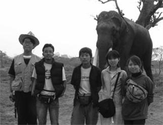
チトワン国立公園には我々は大満足、しかしここで大きな問題が持ち上がります。チトワン入りを強行したため、今度はチトワンから出る交通機関が見つからないのです。そして入ってくる情報と言えば、旅行者向けのバスが毛沢東主義派に火をつけられたというようなものばかり。それでも我々はとりあえず国立公園を離れ、ネパールを東西に貫くハイウェイ沿いに出てみることにしました。そこへちょうどスノウリへ行くというローカルバスが通りかかります。スノウリは我々が目指した国境の町とはまるで逆でしたが、これに乗るしかないと即断し大荷物であったことからバスの屋根へとあがりました。実はカトマンズでも屋根への乗車は試みていたのですがサシームの親に止められていました。我々は思わぬところで屋根乗車を実現し、おおいにこの日本ではありえない機会をたのしみました。
そして遂にインド入国。実は我々は初日のニューデリーに余り良い印象を持っておらず、インドを恐れていました。私の日記には次のように記されています。「かくして地獄の釜の蓋は開かれたのである」。
その言葉通り、インドは入国時から旅行会社にだまされるなど、サシームもネパールとはやや勝手が異なるようで苦戦気味。でもインドではサシームの弟アシームや友達が留学しており、彼らに助けられながら驚くほどスムーズに列車を乗り継ぎ、バラナシ、カルカッタ、プリー、ナプリ、そして再びデリーと駆け抜けて大したトラブルもなく無事旅行を楽しいまま終えることができました。
この旅行中で出会った方々皆さん(我々を騙した人たちも含めてですが)、どうもありがとうございました。この場をお借りして厚くお礼申し上げます。
***********************************
Visit to Nepal and India
Tesukai Shoji
Translated by: Saseem Poudel
This spring vacation 2004, four of us:
Tetsuaki Shoji, Masahiko Obara, Mika Tokuyama and Atsuko Mori traveled to Nepal
and India on the invitation of Saseem Poudel. There are too many memories of
this trip to be able present them all here, but I will try to look back at few
of them focusing the incidents in Nepal.
The plane left Tokyo, transited in Taipei, then
we entered India at New Delhi. After 12 hours stay, we headed towards Kathmandu.
Flight delay resulted our arrival at Kathmandu in the middle of night. Next
morning we met Saseem after about a fortnight, stayed in Kathmandu for about a
week, and visited Nagarkot and Bhaktapur. Received the hospitality of the Poudel
family on the last night of our stay in Kathmandu and they bid farewell to us in
their traditional way. Saseem also bid farewell to his family parting for
another one year.
Probably because we stayed in Kathmandu for the
longest period of the visit, the things those impressed me the most were
Kathmandu and the vicinity. The first morning in Nepal, after meeting Saseem in
our hotel area Thamel, we were taken to eat our first meal in Nepal: MoMo. I had
decided to visit Nepal, after eating MoMo in Japan that Saseem had prepared for
us. Thamel was the entertainment area and we were not able to understand how
people normally go along with their life, but while walking the narrow roads
leading to Durbar square we were able to feel the normal living style of people
there. I saw diversity at a glimpse, but despite of that everything was in order
and people were enjoying themselves with vigorously.
Rows of brick made houses along the street gave
solemn sensation. For me this part was more interesting than the Durbar square.
Thanks to Saseem, we did things like traveling in micro-bus and were able to
know the life style of the people more than the normal tourists. May be it can
be said that Saseem took us around more than he should have, but even as I do
not know how the other three felt about it, I am filled with gratitude for
showing me all those things. After leaving the Durbar square, the statue of the
Rana, the electric town (New Road), and then the white government office
building were seen. It was quite interesting to see two sides of Kathmandu: one
trying accept the new world, other part fixing its legs on the traditional
world. We saw sunrise and sunset of Himalayas at Nagarkot. Japan lies in the
eastern end of Asia, so it is the land of sunrise, in other words the Sun’s(日)
Base(本) from which the name of our country Nihon is derived. We being the
citizens of such country, seeing the sunrise and sunset from the highest point
of earth was a touching experience. Then we went to the world heritage site,
Bhaktapur. The rows of houses in the street charmed us more than Kathmandu.
Guided by the local kids, rushing through the maze like street, bumping my head
and singing resam firiri with them, these all were the memories that I
will not forget easily.
Then in Saseem’s family, we couldn’t help being
touched especially by meeting his two younger brothers. Aseem identical to
Saseem and a bit shy Sameep. Unconsciously we used the video camera we carried
to prepare a short movie about these three brothers. Here is the story:
Saseem Myth
In the ancient age Saseem was divided into two
Saseems. One was Saint Saseem, Aseem. The other was evil Saseem, Sameep.
But in order to beat the enemy from the country
of sunrise(us),they decided to fuse.
Two Saseems shouted “Fusion!!” and dance. Then
complete Saseem appeared and beat the enemy.
With the moonlit night scene as a background we
got a very mysterious movie made.
Then we stayed in Pokhara for about 4 days. We enjoyed the lake shores, caves,
Sarangkot. It was a very beautiful city. Here I ate three steaks in one evening.
Sure enough I caught diarrhea the next day and was sleeping that whole day. I
can never forget the taste of NAVA JEEVAN (Orange Flavoured) that I had to drink
that whole day. After that we left Pokhara by an early morning bus and stayed in
Butwal. That day, we went around birthplace of Buddha, Lumbini, guided by
Saseem’s cousin. Our next destination was Chitawan National Park. But we
received information that due to blockade called by Maosits, transportation
around Chitawan was highly restricted. Until the last moment we were not sure
whether we will be able to make into Chitawan or not and waited inside the bus.
The bus finally moved after noon. We rode on bus, cycle rickshaw, and then auto
rickshaw and finally arrived in our hotel in Sauraha. We split and rode in three
different cycle rickshaws. It turned out to be real entertaining competition
between them. We were fully entertained by their strategies in the race. We took
the video of the race. In Chitawan National Park we entered the jungle riding
the elephant. I gazed at the rhino from the back of elephant and it was the
experience Japanese can never even think about.
We were fully satisfied in Chitawan National Park but a big problem was raised
before us. We had entered Chitawan somehow but now it was difficult to find the
transportation out of Chitawan. According to the information we received, Maoist
had just burned a bus used to carry the tourists. Despite of that we left
Chitawan National Park for the East-West highway. There we found a local bus
going to Sunauli. Sunauli was not the point we planed to cross the border, but
we changed our plans according to the situation and rode the bus on the rooftop
of the bus. We had earlier tried to ride the bus on the roof once in Kathmandu
too, but were stopped by Saseem’s parents. Our dream of traveling in the roof
top of the bus finally came true and we got a chance to experience the thing we
can never do in Japan.
From there we entered India. We did not have pleasant memories of New Delhi from
the first day of our visit, so
were rather afraid of India. I wrote the
following in my diary. “and thus opens the door to the hell.” As the words
express, while entering India, we were swindled by the travel agent, Saseem’s
hard fight against the arbitrary deal of the agents. In India Saseem’s yonger
brother Aseem and his friends were studying. With their help, we rode the
train pretty smoothly. Banaras, Culcutta, Puri, Nagpur, and then once more
back to Delhi; we completed the travel without big trouble and safely.
I would like to thank all the people I met
during this trip (including the ones that swindled us).